LiDAR mapping drone
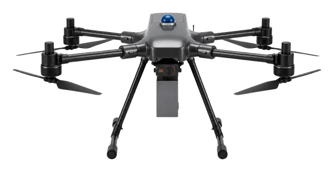
Surveyaan V1 Pro LiDAR drone
Laser scanning and a calibrated camera on one aircraft, for ground that a camera alone cannot see.
- 40–45 min
- flight time
- < 5 cm
- vertical accuracy
- 26 MP
- calibrated camera
- 360°
- obstacle avoidance
What it is
The V1 Pro carries a LiDAR scanner alongside a 26 MP calibrated camera. Laser pulses pass between leaves and return from the ground underneath, so you get a true terrain model in forest, scrub and standing crops, plus a colour orthomosaic from the same flight.
What sets it apart
Sees through vegetation
Multiple laser returns reach the ground beneath tree cover, where photogrammetry only records the canopy.
Point cloud and imagery together
LiDAR and the 26 MP camera capture in the same flight, so the point cloud and orthomosaic line up without a second mission.
360° obstacle avoidance
Sensing in all directions for safer flying near trees, towers and structures.
Works in low light
LiDAR measures with its own laser, so results do not depend on sun angle or surface texture.
Joystick controller with live view
Hard joystick control, 3-axis gimbal and continuous FPV video out to 2.5 km.
Field-ready in five minutes
A pre-calibrated payload and hard carry case mean one operator can deploy it quickly.
Deliverables
Classified point cloud
LAS or LAZ format, ready for terrain and corridor analysis.
DSM and DTM
Surface and bare-earth terrain models as GeoTIFF.
Orthomosaic
High-resolution colour map from the calibrated camera.
3D model
Textured mesh in OBJ format for design and review.
Specifications
Aircraft
- Type
- Multi-rotor
- Category
- Small
- Weight
- 6 kg
- Obstacle avoidance
- 360°
Flight
- Flight time
- 40–45 minutes
- Range
- 2.5 km radial
- Maximum altitude
- 120 m
- Wind resistance
- Up to 25 km/h
Sensors
- LiDAR
- Multi-return laser scanner
- Camera
- 26 MP, calibrated
- Gimbal
- 3-axis
Accuracy
- Horizontal
- Under 10 cm
- Vertical
- Under 5 cm
Software and control
- Point cloud processing
- Windows desktop application
- Photogrammetry
- Cloud software for camera data
- Controller
- Hard joystick with live FPV
- Setup time
- About 5 minutes
Manufacturer’s published specifications, subject to change.
How is a LiDAR drone different from a camera drone?
A camera drone builds a surface from photographs, so it maps the top of whatever it sees. A LiDAR drone measures distance with laser pulses, which reach the ground through gaps in vegetation and give better vertical accuracy.
When do I need the V1 Pro instead of the V1RC Plus?
Choose the V1 Pro when the ground is hidden by trees or crops, when you must capture wires and thin structures, or when vertical accuracy is critical. For open sites the V1RC Plus with PPK is usually sufficient.
What outputs does the V1 Pro produce?
A point cloud in LAS/LAZ, surface and terrain models, an orthomosaic and a textured 3D model.
Is processing software included?
Yes. A Windows desktop application processes the LiDAR data, and cloud photogrammetry software handles the camera imagery.
Which industries use it?
Mining, forestry, civil engineering, utilities and power lines, environmental studies and archaeology.
Have a project in the air?
Send us the site location and what you need to know about it. We will reply with scope, timeline and a quote.
- WhatsApp: +91 99091 00410
- Phone: +91 99091 00410
- Email: info@megatronixvision.com